Matrixian Public takes the next step in the mobility domain by opening up a national traffic sign database, aimed at mobility data management for the public sector. This specific service will start in 2020 and will be shown on the Matrixian Map.
3 million road signs
There are currently about 3 million road signs in the Netherlands. This means that across the entire Dutch road network there are almost 22 signs per kilometer away! This jungle of traffic signs leads to a lot of traffic chaos with all the associated consequences.
So darling Safe Traffic Netherlands that 600.000 of these signs are unnecessary and can even lead to dangerous situations. The reason for this is that road users no longer see the forest through the trees and are confused by all the options. As an example; Culemborg has a roundabout with more than 70 traffic signs alone.
Need
“So there is a need to intervene. There are currently a number of themes that ensure that a large number of boards are removed or replaced. The nitrogen problem means that in the short term the “130 km / h” signs will have to be replaced by “100 km / h” signs. In addition, more and more municipalities have the wish to use sustainable materials, the introduction of bamboo boards is an example of this. ”, Says Luke Liplijn, CEO of Matrixian Group.
Many road signs are now placed without a traffic order. For example, tens of thousands of fines are successfully challenged every year because there is no official traffic order attached to a commandment or ban. If there is no official traffic order for a traffic sign, the traffic rule can no longer be sanctioned. This costs the Dutch treasury a lot of money and is frustrating for many road users.
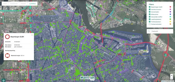
Traffic signs on the map
“The traffic sign data will be exposed on the Matrixian Map. In the first quarter of next year we will start putting the signs of 4 cities online, including all Amsterdam traffic signs. The rest of the Netherlands will follow, the aim is to have all road signs available online on the map by 2020. At the moment we already offer many other data on this card. Think of window times, environmental zones and restrictions of almost all municipalities. For example, navigation software suppliers can take into account areas where children often cross, such as at primary schools. ” Thus Luke Liplijn.
Also read: Speed from March 16 100 km per hour on all highways